Wednesday, May 6th, 2026
As of 12:53PM, 5/6...
WEDNESDAY & THURSDAY
Light to moderate showers racing eastward across the northern tier of the Upstate are losing some steam, and will give way to a drier period by mid-afternoon, earlier than that for some. Showers return by late evening (think 6-7PM or later) with a few thunderstorms possible, again primarily confined to the northern section of the region, and fairly scattered.
Showers/storms become more numerous after dark, with the southern counties getting in on the action. A few of these storms could produce strong, gusty wind, as well as frequent lightning. If you are planning to be out and about this evening, bring rain gear!
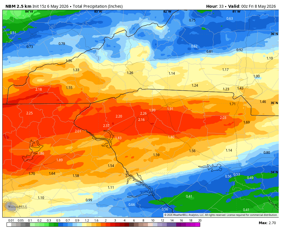
Off and on showers/storms should rock and roll all night and into the first couple hours of daylight Thursday. This has a chance to be our best rain in quite some time, with some models arguing for totals of over 2 inches in some spots. That would double the last 30 days worth of rain! In any weather event, it is always best to temper expectations some, but there is plenty to argue for a nice soaking rain for many in the area.
Showers exit by mid-morning at the latest for our southeastern areas, but a few more scattered showers could develop in the afternoon hours on what will be a breezy, pleasant day for most after morning rains end.
FRIDAY THROUGH SUNDAY
Temperatures bottom out on Friday, with highs generally 70 to 74 degrees, cooler in the mountains. Chilly mornings in the upper 40s and low 50s. No rain concerns for Friday or Saturday! Skies are partly to mostly cloudy, with Saturday bringing the best chance of breaking out into mostly sunny conditions.
Keeping an eye on a potential scattered shower/general rain threat Sunday... at the moment there is disagreement on where the system wants to go, with the GFS arguing further northwest for a cooler, wet Sunday. We'll keep you updated, but nothing is set in stone yet.
AFTER THE WEEKEND
Another cold front may be on the table early next week, which could keep showers in the forecast on Monday. We should get back into a dry situation afterwards, with cooler temps Tuesday.
